Category Archive: Colorado

Dec 20

High Density Lidar for Colorado DOT Applications

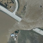
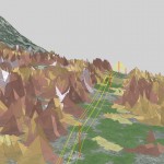
High Density Aerial Lidar of Wray, Colorado (CDOT Front Range NPS – Region 4 – Riverine Design & Analysis) Ayres expands upon its use of high accuracy Lidar for important transportation corridor design and improvement projects throughout Colorado.  In the past year, our Aerial Mapping Services group has been working closely with our engineering staff …

Continue reading »

Aug 10

Capturing an Impressive Display of Aviation History

Ayres Associates and Applied Ecological Services were granted the privilege to capture high resolution digital aerial imagery of the EAA AirVenture gathering in Oshkosh, Wisconsin. Ayres and AES have been partners in aerial imagery acquisition and specialized remote sensing application for over 5 years.  Using a Leica RCD30 we have collaborated on projects ranging from …

Continue reading »

Mar 30

Using Remote Sensing for Forest Regeneration Analysis

Forestry is the backbone of the Menominee Indian Tribe of Wisconsin’s economy. For 150 years, Menominee Tribal Enterprises (MTE) has managed the Tribe’s 235,000 acres and has become an industry leader in sustainable forestry.  In 2007, a tornado destroyed over 2,200 acres of prime hardwood forest, creating a massive impact on future revenue. MTE was …

Continue reading »

Feb 17

Ayres Attends Lidar Conference in Denver

A contingent from Ayres Associates attended the International LiDAR Mapping Forum (ILMF) in Denver February 13-15. Jim Kelly, Jason Krueger, Adam Derringer, and Matt Vinopal   This technical conference is one of the most important national events that our Aerial Mapping group attends each year.  With a bustling exhibit hall and three days of technical presentations, the conference …

Continue reading »

Dec 12

Geospatial Technology for Stormwater Management

Effective stormwater management can make or break a municipalities preparedness for major rain and flood events. Too often municipalities opt for reacting to major storm events, rather than properly preparing for them.  Storm event preparedness is no easy feat and it often takes tremendous effort to identify and prioritize best management practices.  Ayres Associates understands the …

Continue reading »

Oct 26

Integrating UAS into Ayres Professional Services

Unmanned Aerial Systems (UAS), or drones, are becoming increasingly common tool in the survey, mapping, and engineering fields. Incorporating these aerial imaging and mapping platforms into our services is adding new dimensions and perspectives as we measure and observe project sites and structures. This technology is a tremendous tool where site safety and accessibility are …

Continue reading »

Mar 08

Catching up with USGS & 3DEP at ILMF

Ayres Associates sent a contingency of project managers and supervisors to the 2016 International LiDAR Mapping Forum (ILMF) in Denver, Colorado.  ILMF is a technical conference and exhibition showcasing the latest LiDAR advances and emerging remote-sensing technologies.     Our team had a unique opportunity to meet with key staff from USGS staff regarding the ongoing …

Continue reading »

Sep 14

Surveying Steamboat Lake – Above and Below the Water Line

Merging Bathymetric Survey and Aerial Lidar             Ayres Associates is supporting the analysis of the Steamboat Lake with integrated bathymetric and aerial Lidar survey.  Working with GeoSurv Inc. of Lafayette, CO, Ayres conducted a survey of the lake bottom and sub bottom – merging the data with topographic mapping collected …

Continue reading »

Jul 02

Aerial Imagery Captures Recent History of Flooding in Greeley, CO

Flood events in Colorado in 2013 and 2014 have been recorded using aerial imagery- providing the City of Greeley with a valuable tool for assessing flood extent and for analyzing storm water infrastructure and improvements.   In September of 2013, Ayres Associates collected aerial imagery of the South Platte River and its tributaries near peak flood stage, …

Continue reading »

May 01

Ayres Associates Featured in Leica Article on Colorado Floods

Leica Geosystems publishes article about aerial imagery collected during the historic Colorado floods in 2013 http://www.leica-geosystems.us/en/Flooding_pdf_v3.pdf    The article does a great job of highlighting the efforts of the professionals on the user end.  The engineers, floodplain and stormwater managers, surveyors, emergency responders, GIS specialists, and others deserve a great deal of thanks for their hard …

Continue reading »

Apr 14

NoCO (Northern Colorado) Geospatial Consortium

Local municipal governments in northern Colorado team-up to build high accuracy base mapping through LiDAR and aerial imagery.   Ayres Associates worked with several local governments throughout northern Colorado to form an informal consortium with map modernization as their primary objective. This group broadly consists of the City of Fort Collins, City of Loveland, Larimer …

Continue reading »

Mar 20

Mapping Transmission and Distribution Lines with Fixed-wing Lidar Systems

Ayres Associates is mapping transmission lines in the Rocky Mountains of Colorado through the use of fixed-wing Lidar systems.  Poles, conductors, and utility structures are being extracted from high density Lidar point clouds and modeled as vectors in a geodatabase. Much of the focus on as-built transmission surveys over the past few years has been …

Continue reading »