Over two days in early December three Ayres employees attended  the annual ESRI Wisconsin User Group (EWUG) conference at the Hilton City Center in downtown Milwaukee. The conference is a great opportunity for Ayres’ GIS staff to stay abreast of advancements in GIS technology as well as network with other industry professionals. Adam Derringer (Project Manager), Matt Vinopal (Geospatial Supervisor), and Mike Seidel (Geospatial Technician) were on site representing Ayres and Mike also presented and exciting project which is a collaborative effort between Ayres’ surveying and geospatial divisions.
 Many interesting topics were covered and the staff learned a great deal about open data standards, GIS editing tips & tricks, and effectively employing Amazon Web Services. Several of these ideas have already been implemented into day-to-day production with others fostering discussions about data accessibility and visibility for Ayres’ clients.
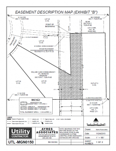
Mike’s talk was entitled CAD to GIS: Easement Mapping Made Easy  and displayed the usefulness of ArcGIS to expedite the mapping of utility easements. The talk emphasized unique applications of ESRI’s Model Builder, Data Driven Pages, Definition Queries, and Python scripting. Models described involved the importing of large volumes of CAD data into geodatabases and formatting of annotation amongst others. It was shown how Data Driven Pages in conjunction with Python can be used in an unconventional manner to utilize the dynamic functionality of the tile index without being beholden to the rigid nature of the application.
This presentation displayed the efficiency of using mapping software with an alternative approach which results in notable time and cost savings over conventional computer aided drafting. It was well-received and highlighted a lesser known service available to Ayres’ clients in the utility or other industries.


Recent Comments